Tropical Forest Research Institute, Jabalpur
Lead Institution
for
Achanakmar - Amarkantak Biosphere Reserve (AABR)
Introduction:
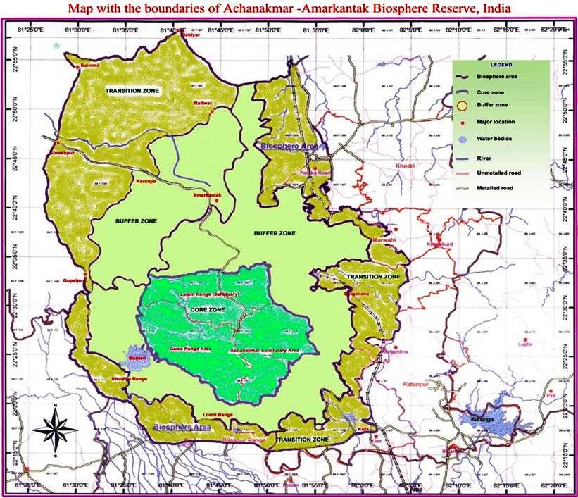
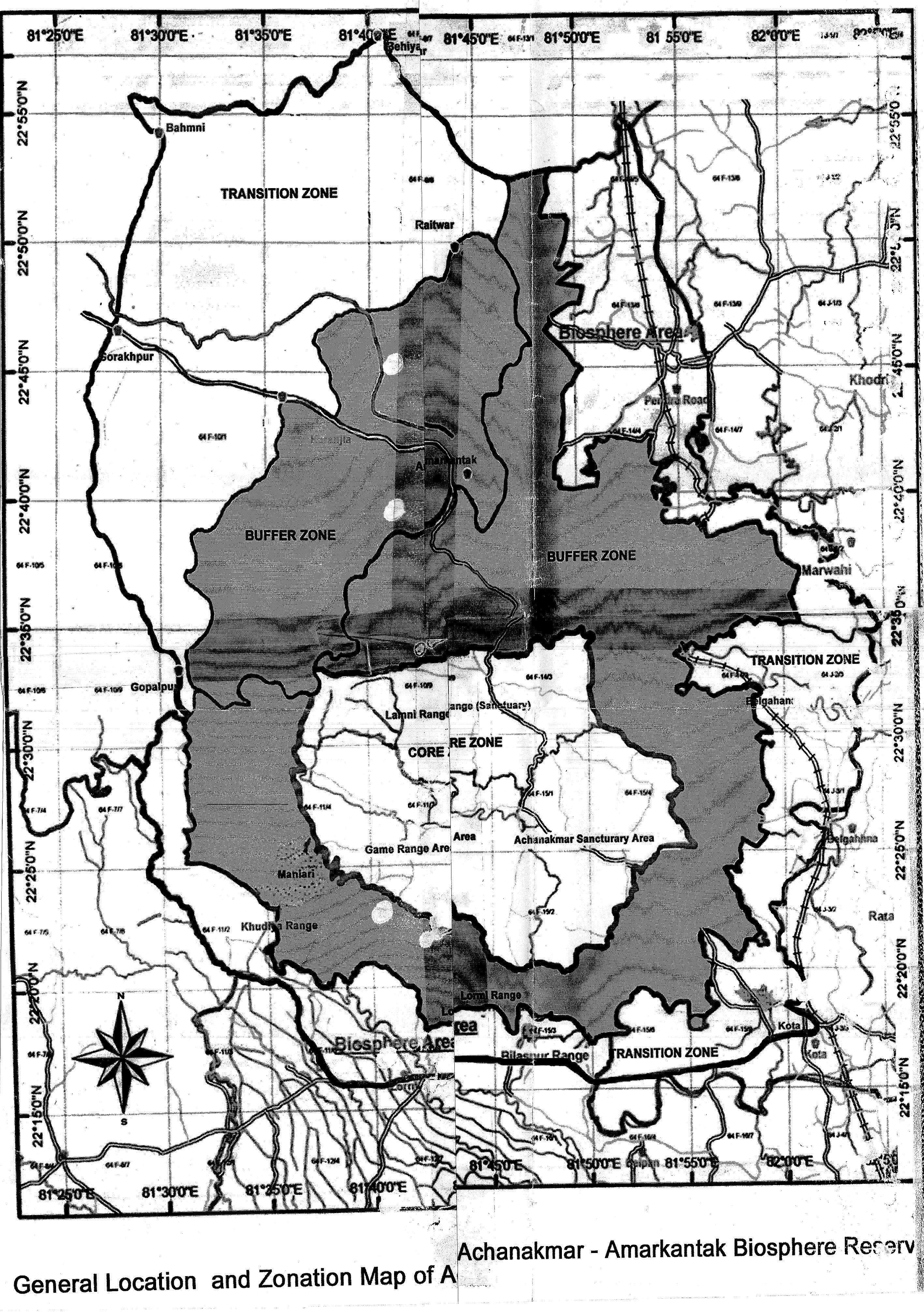
Achanakmar-Amarkantak Biosphere Reserve is named after Achanakmar forest village and Amarkantak, a holy place from where the Narmada, Johilla and Sone rivers emerge. Achanakmar-Amarkantak Biosphere Reserve was declared as Biosphere Reserve (BR) by Government of India vide notification no. 9/16/99 CS/BR dated 30th March 2005. It lies between lat. 220 15’ to 200 58’ N & long. 810 25’N to 820 5’E and is spread from Maikal hill ranges to the junction of Vindhyan and Satpura hill ranges in a triangular shape. Bilaspur and Marwahi forest divisions of the Chhattisgarh state, Dindori and Anuppur forest divisions of Madhya Pradesh state surround the core zone of BR. The total geographical area of BR is 3835.51 sq. km. The core area of the BR is 551.55 sq. km., falls in Chhattisgarh state. It is surrounded by buffer and transition zone area of 3283.96 sq. km., out of which 2058.98 sq. km. falls in Bilaspur and Marwahi forest divisions of Chhattisgarh and 1,224.98 sq. km in Dindori and Anuppur forest divisions of Madhya Pradesh.
Location
 Achanakmar-Amarkantak Biosphere Reserve (BR) is about 60 km far from it`s
headquarter at Bilaspur. It is well
connected by road from
Achanakmar-Amarkantak Biosphere Reserve (BR) is about 60 km far from it`s
headquarter at Bilaspur. It is well
connected by road from
Pendra road railway station, Bilaspur and Raipur of Chhattisgarh and Dindori, Shahdol of Madhya Pradesh.
Topography
Its topography is varied from rice fields in Bilaspur and Anuppur district, and wheat fields in Dindori district to the hills of Maikal ranges of Satpura. The topography, in combination with perennial streams and valleys has created micro-climatic conditions in the area to provide diverse environmental conditions, encouraging luxuriant growth for several species of thallophytes, bryophytes, pteriodophytes (ferns), gymnosperms, angiosperms and many species of wild fauna of economic importance.
Geology
The geology of the area is unique, varied from schists and gneisses with granite intrusion rocks, sand stones, shales, limestone, basaltic lava and bauxite. The soils of the Achanakmar - Amarkantak BR vary in composition and texture from sandy to loamy-clays, generally light brown to brownish yellow in colour. An olive green clay zone up to 5 mm sometimes exists at some places where marshy conditions develop due to poor seepage in these areas. Red soils (due to presence of iron oxide), which is porous and fertile, also occur in some places. Deposits of alluvial soils are also seen on the banks of numerous streams in the tract. The black cotton soil exists in many areas of Achanakmar - Amarkantak BR.
Climate
The BR has typical monsoon climate with three distinctly defined seasons and a short post rainy season. The summer season begins from April and lasts up to the middle of June. The rains commence from middle of June and continue till the end of the September. Post rainy season remains during the month of October. The winter or cold season begins from November and lasts up to March. The mean daily maximum temperature ranges from 240 to 390 C and mean daily minimum temperature ranges from 100 to 250 C depending upon season. A few showers of rain generally occur in every season throughout the year. The average rainfall is 1322 mm to 1624.3 mm. The relative humidity is fairly high due to thick vegetation of sal forest at higher elevations and frequent showers of rain are between June-October. The rainfall decreases to the lowest of 12.98 mm in the month of December. Frost between December-January is often observed to damage Anogeissus latifolia, Diospyros melanoxylon, Kydia calycina, Lagerstroemia parviflora, Litsea glutinosa, Ougenia oojeinensis, Terminalia tomentosa, etc. in Achanakmar and Lamni forest ranges in core zone and Buchnania lanzan, Emblica officinalis, Shorea robusta, etc. at Khandoli in buffer zone.
Achanakmar - Amarkantak BR is blessed with many seasonal monsoon dependent and permanent streams, rivers like the Narmada, the Johilla and the Sone, many rivulets and two dams. Not many efforts have been made to increase infiltration into soil, control excess runoff and to manage and utilize runoff for useful purposes. Old Khudia dam situated in the south-western boundary on Maniary river in the core zone and Malhaniya dam built on Malhaniya river in the buffer zone are the main constituents of the water bodies. These dams are very useful for men and wild animals living in BR particularly during summers when the seasonal nallahs and streams dry up. The water bodies comprise of 33.61 sq. km. areas. The average annual rainfall is about 1624.3 mm distributed on an average over 71 to 118 rainy days in a year, providing ample scope for the watershed management.
Livelihood
The BR constitutes a total of 238 revenue and forest villages inhabited by tribe within Chhattisgarh areas. Of these, 22 villages having a population of 7709 persons are located in core zone and the remainings are situated in buffer and transition zones of the BR. The major occupation of the inhabitants is agriculture besides collection of medicinal plants and other non - wood forest products. They are also engaged sometime as labours by the forest department. The major tribes residing in BR are Baiga, Kol, Kanwar, Pradhan and Gond.
Objectives
Like other Biosphere Reserves of the country, Achanakmar-Amarkantak BR have the following objectives:
To conserve biodiversity of flora and fauna within natural ecosystem.
To safeguard genetic diversity of the species.
To ensure sustainable use of the natural resources.
To provide logistic support to the people, including scientists and academicians, to undertake research activities and share knowledge generated on conservation and exchange of information at national and global levels.
To educate and provide training to local inhabitants for their sustainable socioeconomic upliftment.
News
|
|
Recognition of Achanakmar-Amarkantak Reserve in World Network of Biosphere Reserve (WNBR) by UNESCO |
|
|
TFRI steered Achanakmar-Amarkantak Reserve under UNESCO Biosphere Network |
Publications
Biosphere Reserve Information Series
Field Guide
- Butterflies (Download)
- Birds (Download)
Project Completion Reports (PCRs)
Lead institution projects
CGMFPF project on sustainable harvesting practices on Mahul patta (Download)
DST project on population dynamics of threatened medicinal plants (Download)
Tasar culture in AABR (Download)
Presentations
|
|
Ist meeting of the Indian National Man and Biosphere (MAB) committee on 11th February 2016 (View/Download) |
|
|
Achanakmar-Amarkantak Biosphere Reserve: A Paradise of Biodiversity (View/Download) |
|
|
Achanakmar-Amarkantak Biosphere Reserve under World Network of Biosphere Reserves (View/Download) |
|
|
Achanakmar-Amarkantak Biosphere Reserve in WNBR (View/Download) |
Recommendations for Management Action Plan
Map:
|
|
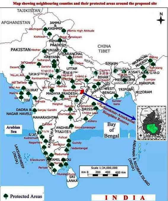
Showing neighboring countries and protected areas. (Click here to view) |
|
|
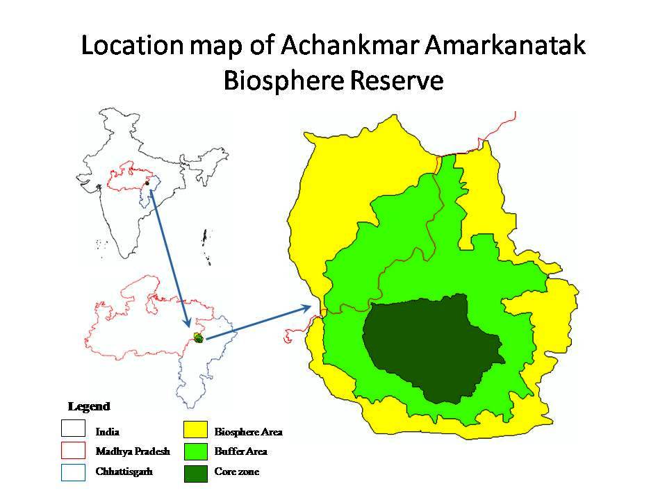
Showing location map of Achanakmar-Amarkantak Biosphere Reserve. (Click here to view) |
|
|
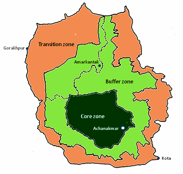
Showing boundaries of Achanakmar-Amarkantak Biosphere Reserve. (Click here to view - Coloured/ Monochrome) |
|
|
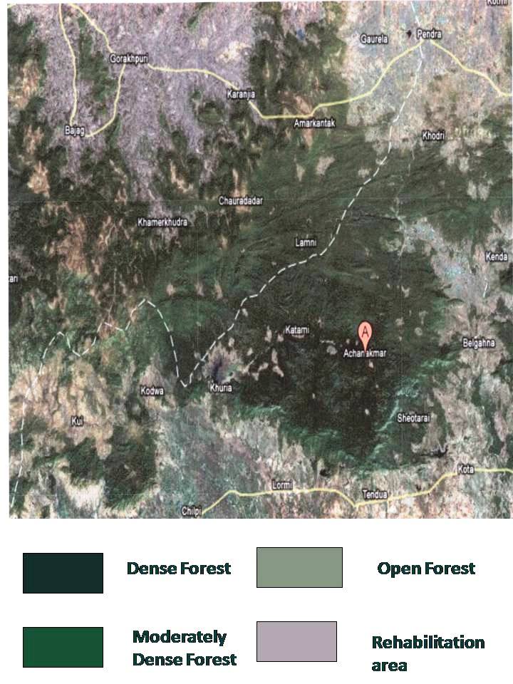
Sowing Vegetation of Achanakmar-Amarkantak Biosphere Reserve. (Click here to view) |